
The aim of this project was to provide a research resource for both the community of East Worlington and for people who might be living far from this small parish in North Devon who have an interest in its history.
The Property Database is a list of all the properties in the parish of East Worlington (and some that aren’t anymore – more on that later) and the names of people who lived in each property taken from information gathered from the UK population census data (1841 – 1921) as well as the census-like data in the 1939 Register.
Each census property has been connected to the modern-day property, and this has allowed us to create a property map. Along with this is a searchable database of people and their occupations.
Because the census in the UK only takes place every 10 years, this is obviously not a complete picture of everyone who lived in the parish but still provides an interesting set of snapshots over a 100 year period at a time when the UK experienced many social and economic changes.
The following sections chart the process of the data collection and analysis.
Source of Data
All the census data was obtained from the genealogy websites Ancestry or FindMyPast. They have published the UK census data between 1841 and 1921 as well as the information gathered at the start of World War II in what is called the 1939 Register. Other identification information was obtained from online newspaper archives and old maps primarily those in the National Library of Scotland.
Initial Collection
The task of retrieving the census data was time-consuming and several people contributed to this initial collection. A shared excel spreadsheet was used at this initial stage and over several weeks a complete set of census sheets was collected from 1841 to 1939. As the data in the census records has varied over time, only a common subset of data that corresponded to data shared by the majority of the census years was retrieved: Property Address, Family Name, First Name, Middle Name, Position in Family, Age, Gender, Occupation and Marital Status.
Even for a parish as small as East Worlington there were thousands of records to find and store in the spreadsheet. Unfortunately, at this initial stage we were not aware of parish boundary changes in 1885 which meant that some properties were missed in this initial collection and had to be added later. You can read about the effect of parish boundary changes on East Worlington below.
Allocating Old Property Names to Existing Properties
Following the initial data collection, all the properties were located in the modern parish of East Worlington and ascribed to a modern property. This was not always a straightforward task and for some properties accurate identification cannot be guaranteed due to either property name changes or individual properties not being well identified in the censuses and also some properties no longer existing (more on this below).
The next task was an attempt to match people from one census to another to aid research into individuals and families of the parish. This was done programmatically and, although checked manually, will undoubtedly contain errors.
Finally, everyone’s occupation was given an occupation sector (such as agriculture, retail etc) and also ascribed a modern description so that different wordings of the same or similar occupations could be grouped together. For example, “house servant” and “house maid” were both allocated to the same “household worker” group along with “general servant domestic” and “farm servant indoors”.
The data was then transferred into a database that could be accessed online through both a map view and a searchable data table.
Issues in the data collection
All the above sounds straightforward, unfortunately reality was a bit more complicated as the following will make clear.
Missing 1939 Data
The 1939 register has many redacted records which correspond to people who are assumed to be still living. Although the data is updated on an annual basis and the records for people born 100 years prior are opened, this means this data may not be complete until 2040.
Errors in original data
There were lots of errors in the census data obtained from Ancestry and FindMyPast. To understand why there were so many it is useful to know the process of how the census data was originally collected and then how the online data was generated.
The process of collecting the UK census information has changed a little from 1841 to this day but remains fundamentally the same. Between 1841 and 1921 every household was provided with a schedule to complete. From 1841 to 1901, these schedules were collected and subsequently transcribed into summary books called Census Enumerators’ Books by people employed as census enumerators. It is these enumerators’ books that you can view on genealogical websites. The original schedules were then, unfortunately, destroyed. Only for 1911 and 1921 is it possible to view the original schedules.
It is in the enumerator books that the first introduction of errors may have appeared as it is likely that some of the original data may not have been correctly copied from the schedules. Indeed, corrections in a different hand can be seen on some pages which indicates that there was a process of checking that took place. Despite this not all errors were caught. Additional transcription errors have subsequently been introduced in the process of digitising the data by the genealogy websites. The websites have done an amazing job, but several factors will have made this transcription process more difficult including: damaged enumerator’s books; difficult to decipher shorthand notation used by the enumerators, unclear handwriting and the archaic writing style; as well as lack of knowledge of local names and locations.
The most common errors were incorrect or inconsistent spelling of names. Other errors were incorrect gender assignment (for example we found more than one female William and a male Mary), incorrect marital status (typically a confusion between M for married and W for widowed). Age was occasional mis-transcribed with people suddenly aging dramatically or rejuvenating between censuses, but this was rare. However, there was often very little consistency in ages between the same people in subsequent censuses. People should have aged by 9 or 10 years (depending on the exact date the census was taken) but they often varied by much more than this, and as much as four or five years. This happened so often that the assumption is that people were either less certain of their date of birth (which unfortunately was not recorded in the early censuses) or it was useful to people to state a different age (for employment purposes perhaps). There was also two unmarried daughters of the Rector in East Worlington who only aged by six years between censuses and maybe this was due to vanity.
Fortunately, both the original enumerator books and the transcriptions are provided on-line so it was possible to correct some of the errors by careful examination of the original enumerator books and the use of acquired knowledge of family or property names. However, this was another time-consuming (but also interesting) process.
Parish Boundary Changes
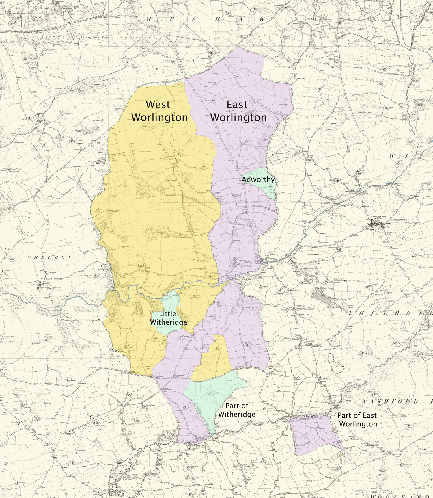
The current civil parish of East Worlington is an amalgamation of the two ecclesiastical parishes of East and West Worlington, along with some other tweaks. The two parishes merged in 1885.
One of the major discoveries of this project was uncovering that prior to 1885 there were a number of properties that are no longer in the parish. Conversely there were properties that are now in the parish which before 1885 formed part of neighbouring Witheridge Parish. This is because historically parishes were ecclesiastical and formed areas that collected taxes (tythes) in order to maintain the local church and to provide a living for the local minister. These were aligned to the local landowners who would have had parcels of land in disjoint areas.
As can be seen from the map below areas coloured blue which are now part of East Worlington were attached to the neighbouring parish of Witheridge. These included an area around the property of Little Witheridge, properties located in an area called Adworthy in the East and also the area around Yeatherbridge Farm in the South.
The most surprising is finding that a completely disjoint area to the southeast around Horridge Farm and Mill was, until 1885 included with East Worlington. This disjoint area is now split between the adjoining parishes of Morchard Bishop, Woolfardisworthy and Washford Pyne.
For more information on this and Devon parish boundary changes see (https://www.martinebdon.co.uk/parishes/).
Identifying Properties
The aim of a UK census is to identify everyone living in a particular household so you might imagine that it would be straightforward to identify households and thereby properties from the census data; and in many cases it was. Unfortunately, for a significant proportion of households this was not the case, and these have been indicated as “uncertain” in the property listings on the website. There were several reasons for this uncertainty.
First, it was common on many of the 19th century censuses to refer to individual properties in the centres of East and West Worlington as “Cottage in the Village” or something similarly ambiguous.
For some census years some of these ‘uncertain’ properties were named (unfortunately not always the modern name) enabling the property to be identified for that year. If the same family was still resident in the village for the previous or subsequent years then we assumed they stayed in the same property and so were able to identify some of the ambiguous properties.
Unfortunately, some of the properties were never named in such a way that we were able to identify them. This was true for Beech and Town Cottages in East Worlington and Stucley Arms Cottage in West Worlington. Similarly, the two cottages in Milltown are often both referred to as Milltown and some uncertainty remains as to the allocation of families to these cottages for several census years.
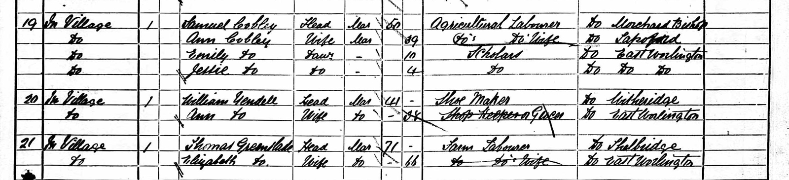
Sometimes guesses had to be made in order to attempt to identify the property. Take the example above, property 20 was identified as The Old Post Office (also known as Laskey’s cottage) based on the following information:
- the census has Annie Yendell living in Laskey Cottage from 1891 to 1921
- what is now called the Old Post Office was the location of the village shop in living memory of some current residents
- Annie Yendell is recorded as being a grocer or shopkeeper for most of this time.
From this the assumption was made that the Old Post Office and Laskeys Cottage are the same property, and as Annie Yendell was living in Property 20 in 1871, this was also identified as The Old Post Office. This assumption is based, therefore, on some reasonable evidence but it may still be wrong as Annie and her husband might have moved between 1871 and 1891 but it is, for now, a reasonable deduction.
Other assumptions were made on even weaker evidence. For example, property 19 above, was also assumed to be The Old Post Office but with less certainty. The primary factors contributing to making this decision was it being adjacent in the census to the property occupied by Annie Yendell for both 1871 and 1881 and for these years there are too many families to fit into the number of properties in the village so more than one had to be multi-occupancy. From visual inspection of the outside of the Old Post Office today there are clear signs that it was once split into two separate units so this property was chosen as the most likely candidate.
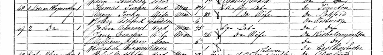
Another issue was that many of the properties that now house a single family were multi-occupancy dwellings. Obvious examples of this were Beech Cottage and the Old Post Office in the centre of East Worlington village, both of which were apparently occupied by two or three households for many of the censuses. Sometimes multi-occupancy was easy to identify as in the case of two families in Lower Blagrove in 1861, which was recorded as “1 Lower Blagworthy” and “2 Lower Blagworthy” (note that the Blagworthy here is probably an enumerator transcription error as the name Lower Blagrove is seen on every other census).
What made the process of identification even more difficult was that a surprisingly large number of people moved either in and out of the area of East Worlington or around in the parish between census dates; so many properties saw a change in occupancy between the censuses. We are therefore aware that it was possible that a family may have moved to another property for any number of reasons so any assumptions based solely on the same family occupying the property may be wrong.
Lost Properties
Another issue with identifying properties was that some of the properties no longer exist because they have been demolished; and for these the use of old maps from the National Library of Scotland was invaluable.
Wallens Cottage
For example, there are people living in Wallens Cottage in four of the six censuses between 1841 and 1891, however, Wallens Cottage does not appear in any census after 1891 and is not a current property name in the parish. Luckily, Wallens Lane and Wallens itself were found on the 1887 and 1903 ordnance survey maps. But as you can see from the current satellite imagery the cottage is no longer there.


1887 ONS map
2025 satellite image
Palace Cottage
A cottage called Palace proved to be harder to find as it does not appear on any of the old maps that are on the National Library of Scotland website. Fortunately, we have the West Worlington tithe map of 1841 and we were able to find it there based on its reference in the apportionment list as “12 Palace Cottage and Close” and it being part of the neighbouring property called “17 Idicambe”.
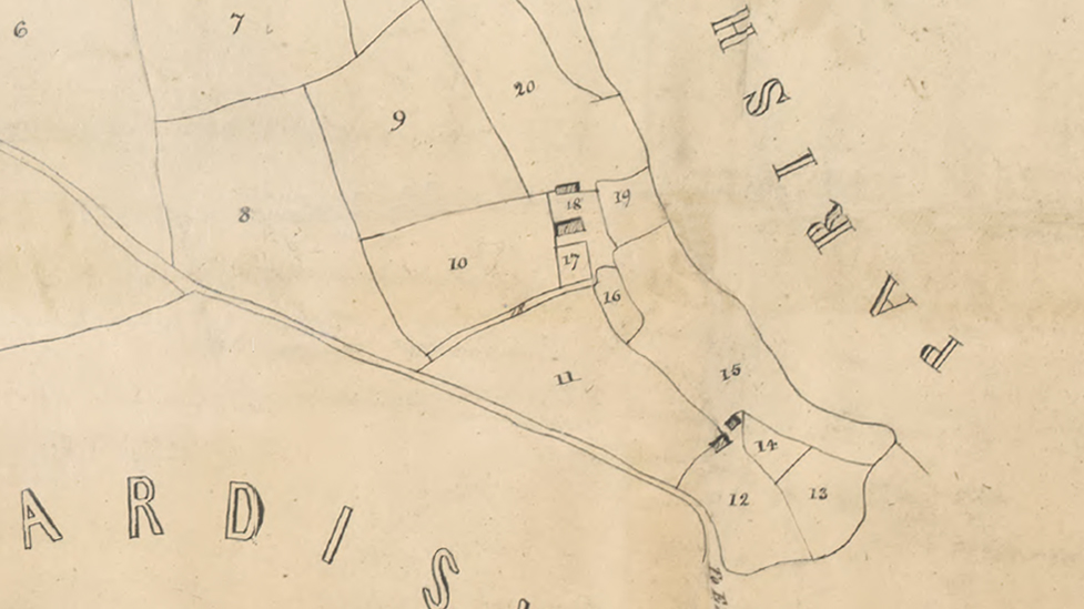
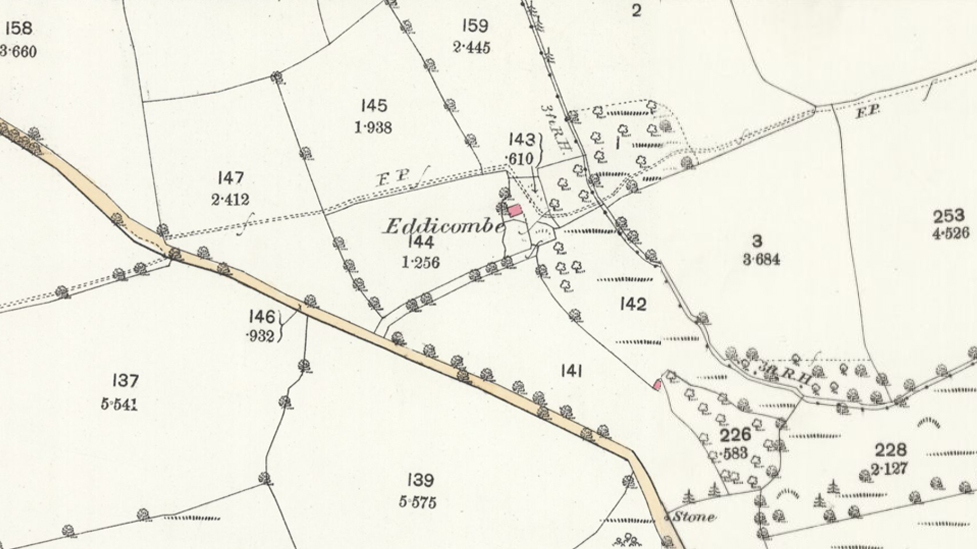
Idicambe and Palace 1839
Eddicombe1888
Idacambe, now called Eddicombe appears on the 1888 Ordnance Survey Map but Palace has appears to have gone leaving just a barn and the 1903 map shows it has disappeared entirely.
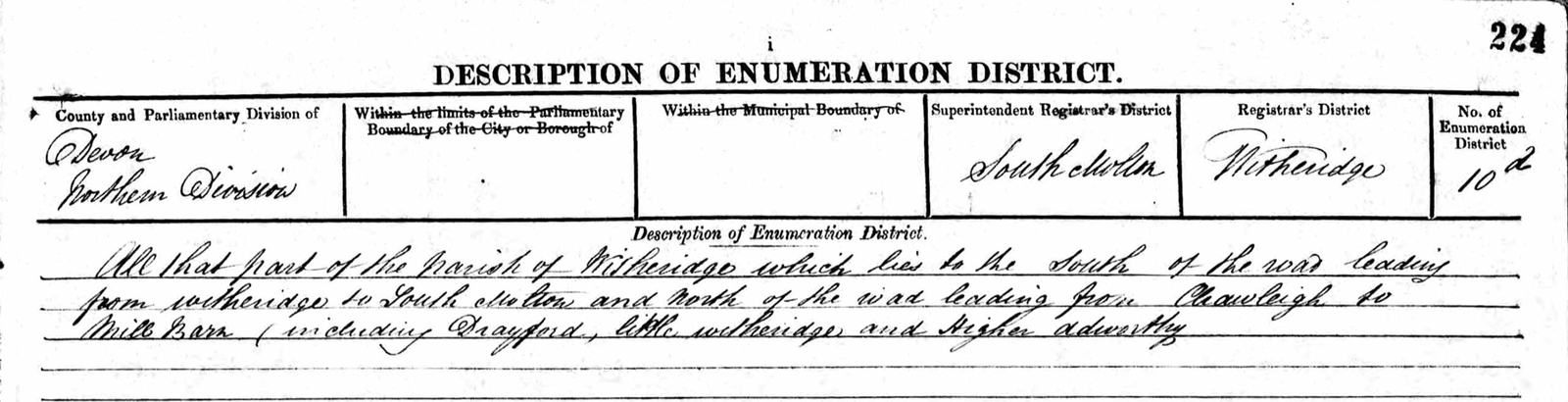
Little Witheridge
Little Witheridge, as we saw from the old parish boundary was, before 1885, part of Witheridge and so was included in the census data for that parish as indicated in the following description of the area covered by the 1891 census for East Worlington:
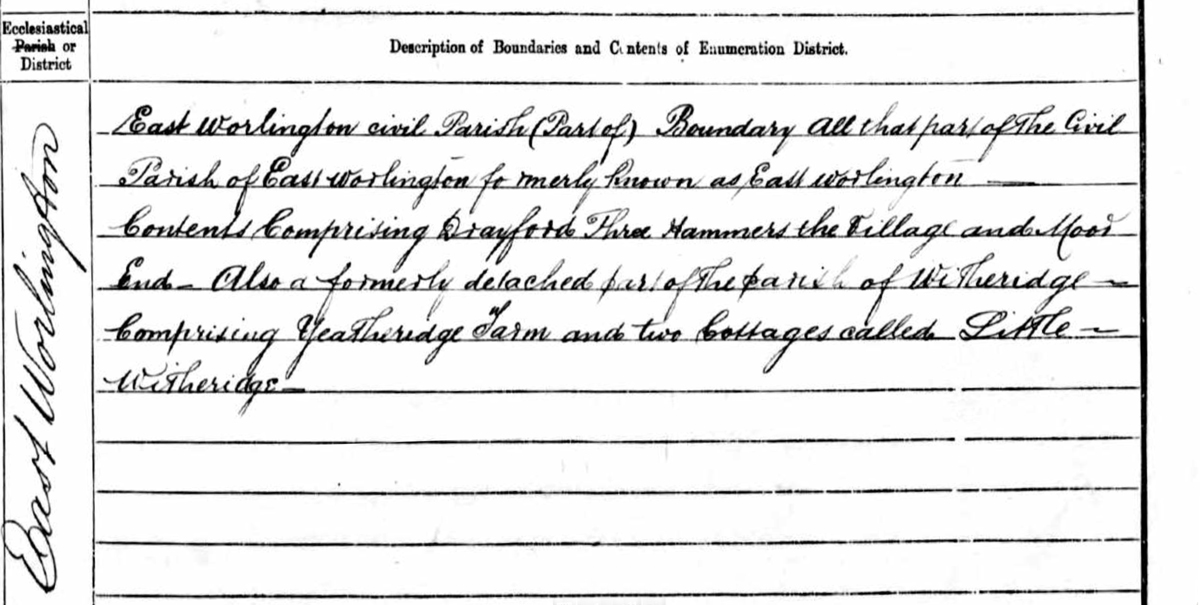
Incidentally the two cottages of Little Witheridge are now one so this was a helpful clue to Little Witheridge being dual-occupancy in the past.
Clatworthy Cottage
A property call Clatworthy Cottage is included in only two censuses:1891 and 1921, and the families in the cottage at these times do not appear in any other property in the parish. It also appears to be an additional property, i.e. not a name change of a previously existing property.
There are a number of reasons why this might be the case. One is that this property has, for some reason, been included in error. There was a Clapworthy Mill in nearby South Molton in the 19th century and a Clapworthy Cottage still exists at that location. Could this be the origin of Clatworthy Cottage and the schedule just became mixed up with the ones for East Worlington when they were collected together?
Alternatively, was there once a cottage, but has since been demolished. From the order in which the census schedules were collated in the enumeration books it would appear that Clatworthy Cottage was located near to the top end of East Worlington Village somewhere between Moor End Cottage and Rock Cottage in Drayford. On the 1837 East Worlington Tythe Map there is a small building marked near to what is now the Old Post Office, which is in the right location. Was this Clatworthy Cottage and because of its size was mostly unoccupied?
Or was Clatworthy an alternative name for an existing property? As the families the occupied the cottage did not remain in the village, without further information it is not possible to be sure of anything about Clatworthy Cottage.
Missing Data
As well as tracking down demolished properties, there was also missing census information for at least two properties: Little Witheridge in 1851 and Thorndon Farm in 1881.
One of the 1851 enumerator books for Witheridge states that it includes Little Witheridge. Despite this, it was not possible to find any entry for Little Witheridge in that the 1851 census.
Thorndon Farm being missing from the 1881 census data is also curious. It is not recorded as being unoccupied, though this was not always done, but while it is reasonable for a cottage in the village to be temporarily uninhabited, this seems less likely for a farm of over 150 acres. It possible that the schedule was simply missed for some reason or not transferred to the enumerators’ book.
Identifying People
Peoples’ ages
One way of attempting to match families or individuals was by finding people with the same name whose age changed by 10 years between censuses. However, there were several problems with this.
First of all, it was not at all helpful that the instructions for the 1841 census stated that age should be rounded to the nearest five years, so ages on the 1841 census were in many cases more inaccurate than other years (it should be noted that not everyone took notice of this instruction). Secondly, as described above, some ages were mis-transcribed on the genealogy websites. Thirdly, peoples’ ages varied between censuses for no apparent reason. This may be due to people being less certain of, or less concerned with, their age or deliberately altered their age for some reason. The variation from one census to another could often be two or more years and in some cases as much as five years.
From 1911 onwards, the original schedules completed by the householders were kept and so one might assume that this information would be more accurate. Unfortunately evidence from the 1911 and 1921 censuses showed that in some situations this was not the case; people still didn’t seem to know how old they were.
However, when people stayed in the area, were reasonably consistent with their age, and did not change their name, we were able use the aid of a computer program to match people from one census to another to create a list of people in the parish.
Women
With the above caveats, the matching process worked well for men but for women who changed their family name on marriage it was not possible to track the vast majority before and after marriage. There were a very few of exceptions to this.
First is Ellen Boundy. Ellen was born in 1868 and by 1911 was married and called Ellen Bulled but, for some reason, was listed as Ellen Boundy / Bulled in 1939 after she was widowed. What makes it more certain that Ellen Boundy and Ellen Bulled is the same person is that her middle name was Halse and this is listed on all but the earliest census where she is know as Ellen H Boundy.
Another is Thomazin Davey born 1824, who also became a Bulled some time before the 1851 census. She is identified as the same person because of her unique first name and her age is right in both censuses.
The only other one is Elizabeth Hosegood, born 1833 who appears to have left home to get married and became Easterbrook sometime after 1851 but reappears in 1861 with her 3-year old daughter Lucy Easterbrook. By 1971 Elizabeth is once more recorded as being single and has resumed using the name Hosegood. Interestingly, her daughter Lucy is also known as Hosegood by this time.
The only way to improve the matches for the women of East Worlington would be to look for marriage records. This unfortunately is a significant piece of work which would take some considerable time and so is beyond the scope of this project.
Occupations
Occupation was recorded on all the census records, but unfortunately with no consistency in the naming of occupations. In order to be able to answer questions like, how many domestic servants worked in the parish, it was necessary to amalgamate various occupations into one occupation category. These categories were chosen to be descriptive but gender and age neutral. At the same time occupations were allocated to an occupation sector, one of :
agriculture
business, finance, legal
domestic
education
faith
healthcare
hospitality and retail
manual labour
not in employment
services
trades and crafts
transport
unspecified
For example all the following occupations were put in the domestic sector and allocated the occupation category of ‘household worker’.
Assistant Farm Household
Domestic
Domestic Help
Domestic Servant
Domestic Servant general
Domestic Servant housemaid
Domestic Servant indoor
Domestic Service
Farm House Duties
Farm Servant Domestic
Farm Servant indoor
Farm Servant indoors
Female Servant
Footman
Gen Servant Domestic
General Domestic Servant
General Servant
General Servant (Domestic)
General Servant Domestic
House & Parlourmaid
House and Dairy Work
House Maid
House Servant
Housemaid
Housemaid Domestic
Housemaid Domestic Servant
Maid of all work
Page Domestic Servant
Pageboy
Servant
Servant Domestic
Washerwoman
Working assistant Domestic
A similar process was done for all the occupations.
In 1841 only one female was recorded as having an occupation and in general women were often recorded as simply being ‘Wife’ or ‘Carpenter’s wife’. This meant women were underrepresented in the occupations. On some census records the wife’s occupation was noted as ‘Unpaid Domestic Duties’ and so the decision was made to make all wives unpaid household workers where no other occupation was given. It is very likely that many wives did much more and also helped with their husbands occupation or earnt money in other ways but this unfortunately was not recorded in the census data.
The allocating of occupation sectors and categories for all 4,285 census records took some time and there will undoubtedly be some mistakes and not everyone will agree with the decisions make on what sectors and categories to allocate to each occupation. The original occupation has been retained so that this can be reviewed if needed.
Final Words
Altogether 4285 census records were retrieved and analysed. Some very interesting and surprising things were discovered, click here to read more and many hours were happily spent deciphering census records, trying to work out where families lived and how property names changed over time. However, the project is not finished. The 1939 data will need to be updated as new records are released and hopefully new information will come to light that will help to remove the uncertainty of some property names. So if you have any information that you think will improve the data do let us know using the Contact Property DB Team in the menu.