|
|
|
|
|
|
Location of the School
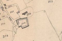
The map on the left focuses on the central area of East Worlington village. Plot 336 is recorded as the Church and Church Yard and plot 333 Horse Park which is identified as arable usage. Both plots are Glebe land and owned by the Church in the name of the Rector of East Worlington at the time the Reverend Benjamin Clay. Plot 335 is named as House and Court and is the Rectory where Reverend Clay lived. Built of cob walls it would originally have a thatched roof. In 1727 it consisted of three rooms on the ground floor with a chamber over. It was rented by the Church from the Earl of Portsmouth, local landowner, and was used for a meeting and drinking place. Tithe Map 1839During the early part of the C19th it was used as a poor house. This was confirmed in the 1851 census when it appears as Church House and was occupied by paupers. Church House, renamed School House in the 1871 Population Census when the resident was recorded as John and Jane Lemon. John’s occupation was named as schoolmaster. |
|
|
|
|
|
|
|
|
|
|
|
|
|